
DALLAS – North Texas is facing a significant severe weather event Sunday night, with the potential for widespread damaging winds, large hail, and possible tornadoes.
Sunday Forecast
Dallas weather: June 8 evening forecast
Ali Turiano gives the latest in severe and tornado warnings across the DFW metroplex. The flood threat continues to rise and 80+ MPH high winds is also expected to be in effect.
Big picture view:
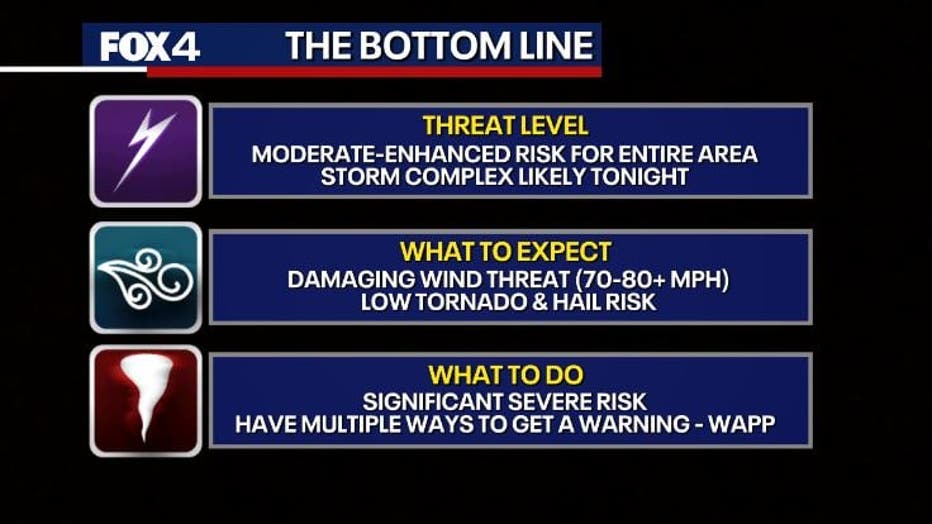
The primary threat will be powerful, straight-line winds, with gusts potentially reaching 80 to 95 mph as a line of storms moves through the region. The Storm Prediction Center has issued a Level 4 out of 5 “moderate risk” for a large portion of North Texas, indicating the potential for a significant severe weather outbreak.
“This has the potential to be one of the greatest severe weather events that we’ve seen so far this spring, just with that high wind potential,” Capps said. She noted that winds of that magnitude can cause damage equivalent to an EF-0 or EF-1 tornado.
Emergency Response Resources
What they’re saying:
Governor Greg Abbott announced that he has directed the Texas Division of Emergency Management (TDEM) to activate additional state emergency response resources ahead of increased threats of severe weather and flooding expected to impact the state over the next several days.
“Texas stands ready to deploy all necessary resources to support Texans as severe weather moves across our state that has the potential to bring flash flooding and heavy rain,” said Governor Abbott. “Texans are urged to remain weather-aware, regularly check road conditions, and heed the guidance of state and local officials to ensure the safety of themselves and their loved ones. Regularly monitor roadways before traveling and check TexasFlood.org for flood information. Remember: Turn Around, Don’t Drown.”
At the direction of Governor Abbott, the following state emergency response resources remain available to support local severe weather response operations:
- Texas A&M Engineering Extension Service (Texas A&M Task Force 1 and Texas Task Force 2): Swiftwater Rescue Boat Squads, Type 3 Urban Search and Rescue Teams
- Texas Division of Emergency Management: The State of Texas Incident Management Team to support deployed emergency response resources across the state
- Texas National Guard: Personnel and high-profile vehicles to assist stranded motorists
- Texas Department of Transportation: Personnel monitoring road conditions
- Texas A&M Forest Service: Saw Crews to assist with clearing of roadways, Texas Intrastate Fire Mutual Aid System (TIFMAS) Strike Teams to support local emergency services
- Texas Parks and Wildlife Department: Game Wardens, rescue boat teams, and helicopters with hoist capability to assist with flood rescues
- Texas Department of Public Safety: Helicopters with hoist capabilities, Texas Highway Patrol Troopers, and the Tactical Marine Unit
- Texas Department of State Health Services (Texas Emergency Medical Task Force): Severe Weather Support Packages consisting of medics, ambulances, and all-terrain vehicles
- Texas A&M AgriLife Extension Service: Disaster Assessment and Recovery Agents, as well as County Extension Agents to support agricultural and livestock needs
- Public Utility Commission of Texas: Power outage monitoring and coordination with utility providers
- Railroad Commission of Texas: Monitoring of the state’s natural gas supply and communication with the oil and gas industry
- Texas Commission on Environmental Quality: Air/water/wastewater monitoring
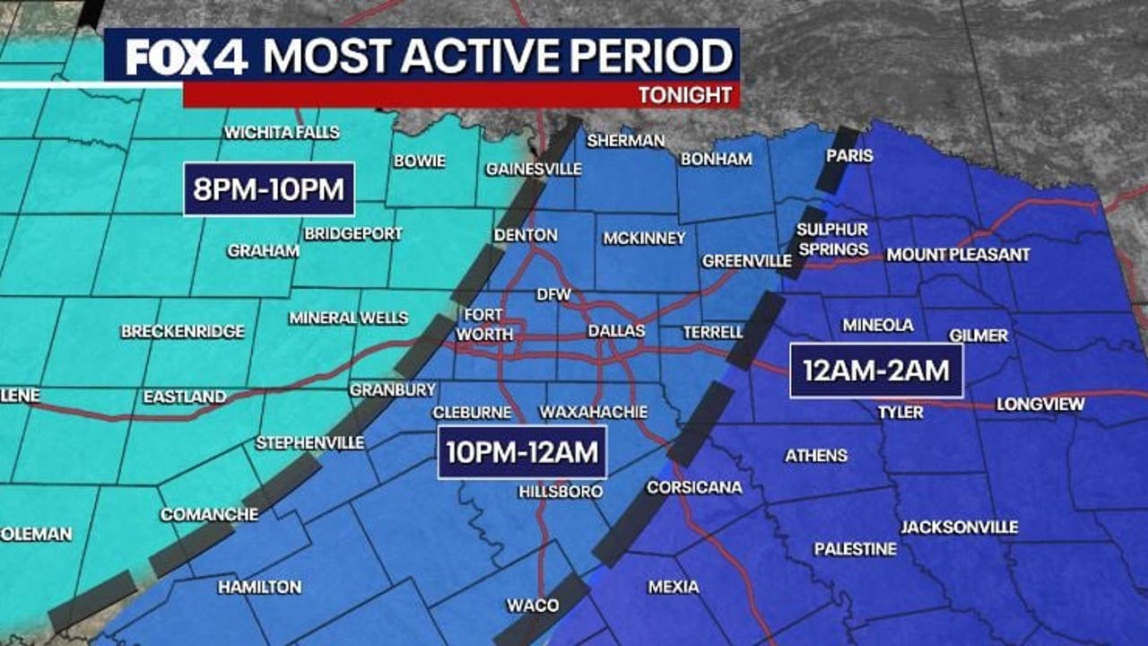
Timeline:
The line of storms is expected to approach northwestern North Texas around 8 p.m. and move into the Dallas-Fort Worth Metroplex between 10 p.m. and midnight. It is forecast to exit the area to the east and southeast between 1 a.m. and 2 a.m. Monday.
“The initial storms that move in from the north and west will have that tornado threat, as well as a large hail threat, but wind continues to be the greatest concern,” Capps said. An increasing flood threat is also a concern due to the potential for heavy rainfall.
Live Radar

Earlier Sunday, scattered showers and some thunderstorms were reported in the far eastern and northeastern parts of North Texas, with some storms crossing the Red River producing hail.
Daytime hours on Sunday are expected to be hot and humid before the storms arrive. High temperatures are forecast to reach the low to mid-90s, with a heat index making it feel like 100 to 104 degrees.
The active weather pattern is expected to continue through the week. Multiple rounds of showers and thunderstorms are in the forecast from Tuesday through Thursday, bringing a continued threat of heavy rain and potential flooding.
7-Day Forecast

Residents are advised to stay weather-aware, have multiple ways to receive warnings, and secure outdoor objects that could become projectiles in high winds.
The Source: Information in this article is from the FOX 4 Weather Team.

